Sunday, September 27, 2009
Drywood, Sept. 26th (2009)
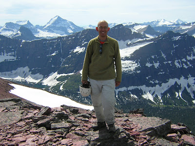
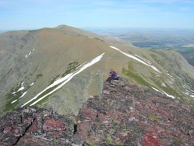
James Y. and I headed out for some top-rope practice at Drywood this past Saturday. James had been there before but it was my first time climbing there. There are a number of bolted routes that can be top roped by scrambling up the west side, passing between the cliff face and a cool gendarme. We left Lethbridge around 8:30 and by time we drove out there and got all our bikes and gear sorted out it was 10:15 AM. We brought a couple of ropes and way too much stuff.
We biked as far as we could and slogged our way by foot with our heavy bags to the cliffs. There are a number of bolted routes on some cliff faces below an adjoining ridge of Drywood peak and arrived at the Ram's head around noon. I hadn't realized how much time and effort it would take to get to the cliffs (about 350 m elevation gain to get to the cliffs) but it was almost worth the hike just for the impressive views below.
The routes from Goble's book were a lot tougher than anticipated! I could only muster getting up the easiest sport route and could barely get partway up the other rope we set up. J. tried a lead climb towards the end of the day.
Biking in the morning was a slog and it was crazy windy, so it didn't feel like we were saving much time on the way up (but it definitely was worth it biking out). We were driving out by 5 back in Lethbridge by 6:20.
Some useless stats for the day:
El. Gain: 1135 ft (346 m); Car: 5133 ft (1564 m), Cliffs: 6267 ft (1910 m)
Round Trip Distance (9.5 km)
Tuesday, September 15, 2009
Calf Robe Mountain (Sept. 14th, 2009). East Glacier area, Glacier National Park
K. and I camped with J. and C. (and little Tristan) at the Two Medicine Lake campground this past Sept. 13th and 14th and did a couple of pretty good hikes.
J and C actually brought Tristan along for a couple of huge hikes in a backpack and were impresively well organized (almost with military precision) to deal with all the various things that babies throw at a guy - poopy diapers, feed-me fits etc. Tristan actually was really good though, aside from not sleeping completely through the night in their tent trailer.
Saturday we hiked up Scenic Point (see previous blog entry) and Sunday we tackled Calf Robe Mountain. Pix follow below.
See route description on trailpeak
Monday, September 14, 2009
Scenic Point (Sept. 12th, 2009), Two Medicine area, Glacier National Park
Scenic Point is a minor peak in front of Two Medicine Lake in East Glacier. The well maintained trail continues past the viewpoint all the way to the village of East Glacier. We stopped at Scenic Point and enjoyed the great weather and views of the mountains to the west and the prairies to the east. We could even spot the Sweetgrass hills off in the distance.
We were tempted to continue further afield to Medicine Point but decided to save that for another day. An interesting ridgewalk described in the climber's guide is to do a big loop starting on the trail and hitting Medicine Point, Mt. Henry and Mt. Appiskoti all in the same day. From Mt. Henry you would drop to the saddle between Mt. Henry and Appiskoti and then either go back down from the saddle, or run up to tag Appiskoti and then descending via the saddle back down the drainage and eventually crossing the drainage and rejoining the scenic point hiking trail.
Elevation gain: 682 m (2,240 ft)
El. at summt: (2,292 m) 7,522 ft
Distance: 12.3 km (7.7 miles)
5 hours round trip including lots of breaks.
Tuesday, September 01, 2009
Bad Marriage - Eagle Plume - Mad Wolf traverse with James Y.
Climbing up a mountain can be just like a bad marriage. Our ascent was not unlike this peak's namesake, with more than a few moments of soul sucking uphill bushwhack. However, once up high on the open ridge, we forgot all about the bushwhacking and enjoyed a fantastic ridgewalk.
Unsure of the descent route off Bad Marriage, we decided to do the traverse in reverse and start off by ascending BM and descend off of Mad Wolf, which we could see looked straight-forward. We had also been forewarned not to drop down off of BM by the drainage as there were some cliffs adjacent to the waterfalls. I was hoping to find a weakness in the cliffs on the way up but as we hiked up the trail, the cliffs on the North face of BM looked like an impenetrable fortress. Finally, we hiked all the way up the valley and passed the interconnecting stream coming out of Triple Divide Pass, and found a more moderate approach that took us right up. Hiking further upstream made the first stream crossing much easier and other than being really frikkin' cold, was no biggie.
Views from the ridge were pretty grand. Lots of snow in every direction and the ridge walking was great. The connecting ridges from BM to eagle Plume was straight forward, as was the walk from Eagle Plume to Mad Wolf (despite appearances). On the descent we spotted a pair of bears far off below... reminded us a lot of the scenic point (Mt. Henry-Apistoki) traverse last year!
There were some good game trails from the reservation horses that seem to have taken over this corner of the park that we were able to follow through the meadows almost all the way back to the last stream crossing. The stream crossing at the end of the day was unforgettable (neither one of us swam but it was dang close! The water was generally 3-4 feet deep but I sank almost right up to my neck at one point when I found a deep pool right at the edge where the water velocity was zero). Cold water wakes a guy up, that’s for sure!
The drive home was an adventure, a moose popped out in front of the car at one point and we barely made it accross the border in time (there was a 10:40 PM Sunday traffic jam happening...) When I told the border patrol dude we were hiking in the Cutbank area, he thought we were hiking in the town of Cutbank and commented that he did not think there was much hiking to do in that town and asked if we had been hiking in the coulees... being tired, I almost could not remember the names of the mountains we had been on and I made quite the long awkward statement when I clarified where we had been, "We were up..." (pause) "Bad Marriage mountain... and" (pausing longer) "Mad Wolf mountain" (pausing one last time) "in the Cutbank camground area of Glacier Park."
Luckily he let us through. I was still pretty wet from the stream crossing and was happy we did not get searched!
Subscribe to:
Posts (Atom)