A weekend of peak bagging was long planned, coninciding with Kristien and Nicola's trip back east...
The forecast for the weekend changed unexpectedly on Friday to rain. We had been planning a mountaineering ascent of Mt. Wilbur, but that would have been completely foolhardy to attempt, given such lousy weather predictions! Gloomy weather was expected for all of the mountain ranges within a reasonable drive from Lethbridge. The storm-front extended as far south as Glacier and as far west as Fernie... all the way north to Jasper. However, early on Sunday morning, the weather forecast had improved, albeit ever so slightly. Looking at the online sattelite and radar imagery, as well as the GNP park webcams, Glacier Park looked promising enough to warrant a trip. To salvage the weekend, we figured that our best bet would be a rainy day hike. Discussing the slight improvement in the forecast, we worked ourselves up into thinking that the weather might even be favourable enough to scramble up a front range peak! So off we went, two suckers from the city to try an ascent of Elk Mountain or Little Dog in the Marias Pass area.
We stopped in at the Teeple's IGA in Browning and arrived finally at Marias Pass late in the morning. The clear skies we had experienced on the prairies were disappearing and clouds were ominously starting to billow over the front ranges. 15 or so minutes into our hike, the skies opened up and we started to get wet. A young gal was trail running and surprised us a couple of times, dashing past us a couple of minutes into the hike, then later darting back in the other direction when it started to rain to rush back to her campsite, as she explained while jogging by, to put her gear away. After sitting under a tree in the rain for a bit, we heard some not-so-distant thunder and also made the decision to turn back.
We decided to salvage the day by driving back through the park via St. Mary's to check out the interpretive centre. However, arriving at St. Mary we were astonished (and somewhat dismayed) to see that it looked positively clear up at Logan's Pass! James had attempted Heavy Runner a couple of weeks back with his girlfriend Kyla, so the approach was fresh in his mind. Although J. had already been chased off Heavy Runner on that attempt by poor weather, he figured it would only take 2.5 hours to make it to the top and was willing to give it another shot, again under less-than-ideal weather. Given that the skies seemed to be clearing in that area, we figured we could make a dash up as long as the weather held and would turn around if it started to rain. It was a fool's mission, but somehow it worked out well!
The boardwalk at Logan's Pass was packed (as usual) with tourists and there were a few snowboarders playing around on the remaining snow covered slopes. Starting on our way at 2:30, James noticed that a bunch of snow had melted in the two weeks that had passed since he had last been in the area. The park had also posted signage with an accompanying map that directed hikers and skiers to keep off the 'hanging meadows', which were now free of snow. The requirement to stay on snow and circle above the meadows significantly lengthened the approach. James had previously gone as-the-crow-flies to the approach of Heavy Runner, (since the meadows were at that time still snow covered). The saddle between Mt. Reynolds and Heavy Runner, James figured, was best gained by traversing the lower North facing slopes of Mt. Reynolds. To stay on snow, we were required to head further up the Hidden Lake trail and skirt just below the Mt. Reynolds approach trail, gaining some unnecessary elevation.
 |
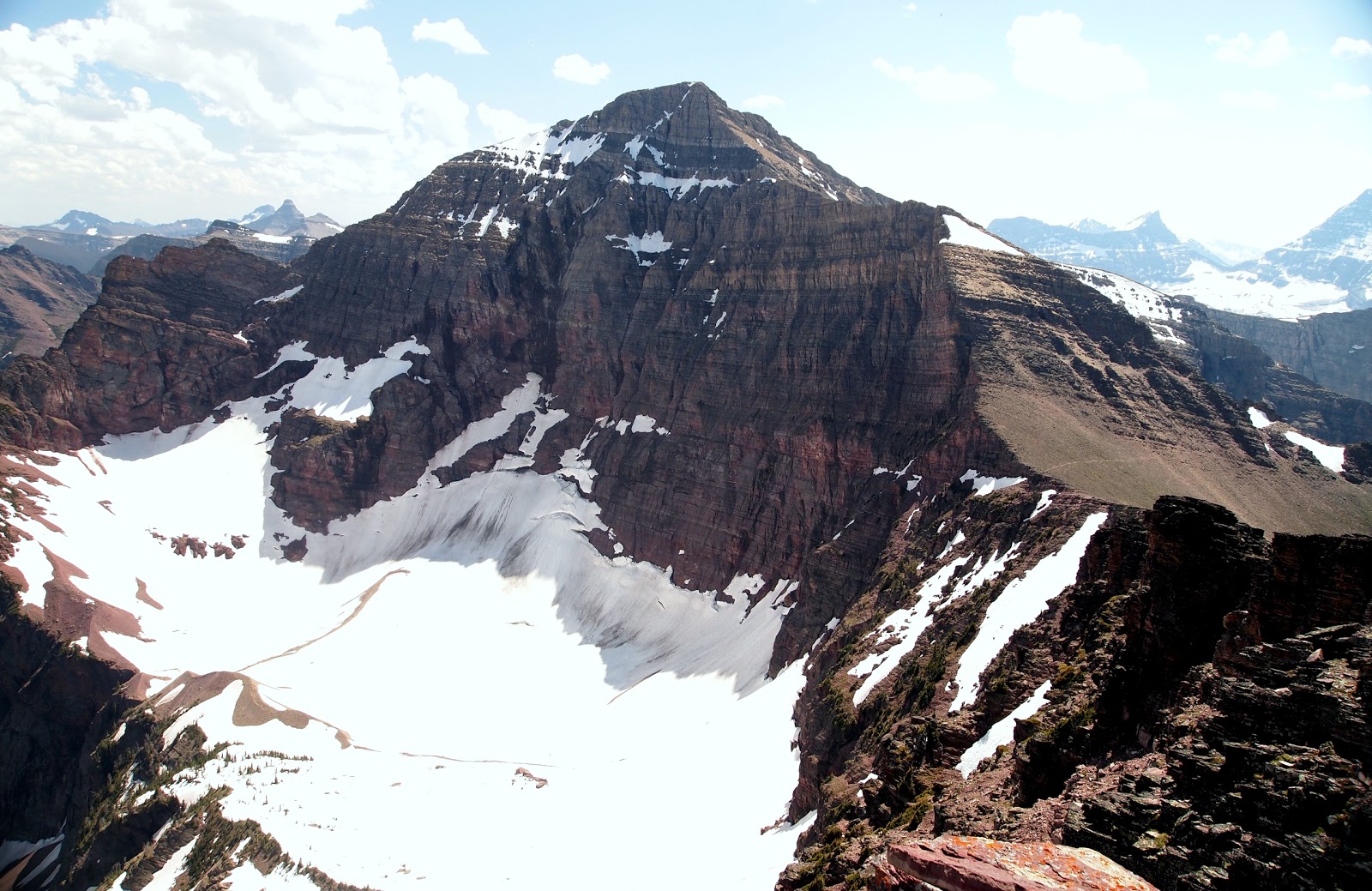
| Photo 1. The long traverse below Mt. Reynolds |
We found our way down to the the valley floor and finally we made it to the base of Reynolds. We ascended a short snow slope to begin the traverse of Reynolds north facing slopes (above the cliff bands). I stupidly forgot to bring my ice axe, but luckily that one snow slope was the only real place where an ice axe would have been handy. Once on the traverse, we were able to thread the needle between the snow patch above us and the cliffs below. The traverse wasn't fun, as it was ankle twisting stuff - not to mention above a tremendous drop - on sloping terrain. We were at times able to follow faint goat trails that made the travel easier.
 |
| Photo 2. The ridge and St. Mary Valley |
Once we gained the ridge proper, the views were tremendous and the scrambling on the summit block was a hoot. It rained lightly at times but it never poured, with the clouds billowing behind us, blowing up the pass from the other side. We took a few photos on the 1st summit and remarked that the 2nd summit was indeed a few feet higher. I recalled reading somewhere that the far summit was class V. Although we had no climbing gear and there was some precip sprinkling intermittently, we decided to drop down to take a look at the climber's summit and possibly find a scrambling route to the top.
 |
| Photo 3. The summit blocks. |
We circled the south half of the last summit block and found a cool chimney that went a short ways up, but as we had no rope, we didn't go above the chimney. We could see three solid holds about a metre apart above the chimney that would take you above the most difficult stuff, but it was a vertigo-inducingly exposed, so we called 'er a day and decided to head back. A couple pieces of protection (with a long runner) would be adequate; there is a big mushroom feature at the top that we could see others had wrapped with sling/webbing to rappel down.
 |
| Photo. Taking a look up the chimney at the 2nd summit. |
Made it back to the car at 8:15 PM (5h 45min car to car at a moderate pace).
 |
| Photo. Clouds would periodically roll up the valley but we never got rained on too hard on Heavy Runner. |
 |
| Photo. A peak peeking out of cloud cover. |
Notes to self:
1. Come back on a nice day with camera ready and rope in tow!
2. In summer when the snow is gone, the park denotes the meadows as off-limits to prevent trampling by tourists, so the approach would be even longer. As it was, we were able to stay on snow until we reached the small patch of forest just before the cliffband that drops to the valley, between Reynolds and the upper part of the snow covered meadows.
3.
We decided to salvage the day by driving back through the park via St. Mary's to check out the interpretive centre. I also wanted to scope out an approach via the Blackfeet reserve to Yellow Mountain off the Chief Mountain Highway.
4.
A couple pieces of protection (with a long runner) would be adequate; there is a big mushroom feature at the top that we could see others had wrapped sling/webbing around to rappel down. (5 m of webbing of might be required to fit around the rock at the top for a rappel, if it is 1.2 to 1.5 m in diameter. A 20 metre rope would be enough to belay someone from the chimney).
5.Left Lethbridge a bit after 8:30, excluding the stop at Teeple's it was about 2 hours to east Glacier
6.
I stupidly forgot to bring my ice axe, but luckily that one snow slope was the only real place where an ice axe would have been handy. The snow slope to ascend above the cliffbands to the traverse of Reynold's lower slopes was only of moderate consequence, there was a fairly mild snow covered runout on the far end so hitting the scree slope at the bottom in the middle was the worst case scenario, so even if you slipped and could not self arrest, you would probably escape with, at worst, a bruised butt and ego.
7.Driving accross the border at Del Bonita, the U.S. customs dude seemed pretty suspicious of us. So try to look as clean cut when as possible when passing through the Del Bonita border! Even though this border crossing significantly reduces the driving time required to get to Two Medicine/East Glacier, I don't think many people bother to drive through here. He asked us the usual questions, plus had we criminal records or ever been fingerprinted, etc. The question I found most odd was if I had ever travelled on a foreign passport. I didn't even understand the question right away, but luckily he just let it go and did not search our vehicle or delay us further.
 |
Photo. Heavy Runner as viewed from Going to the Sun road (Reynolds is on the right). A late start by a couple of stupid, stubborn scramblers from Southern Alberta.
|