Tuesday, August 25, 2009

Iceberg Peak (August 24th, 2009)

From the summit of Iceberg peak we had awesome (but somewhat vertigo-inducing) views looking straight down upon Iceberg Lake... To the north the sea of peaks include Ahern, Ipasha and Merritt; Wilbur dominates the view to the to the south. Swiftcurrent mountain fire lookout and the southern end of the Highline trail can be spotted as well.


Another group scrambled up with us to the notch (they hiked to the notch and did a loop descending below Swiftcurrent mountain to the trail and back to Many Glacier).
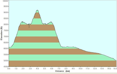


Ascending to Iceberg notch was really fun (solid class III the entire way). I was apprehensive about descending this way but it worked out fine... one just had to be careful not to trip on all the marbles that cover the ledges.

Other possible descent routes that we discussed were: 1. descending to the Highline trail below and following it back to Swiftcurrent pass and back to Many Glacier. 2. Descending to a saddle between Swiftcurrent mountain and from there dropping down via a goat trail, crossing above Windmaker Lake to the Swiftcurrent trail (this route was a bit exploratory... but David, a dude in our group had done it years before... we discussed it briefly with the other group that we met ascending to the notch and they managed to pull it off (we met them back at the parking lot at the end of the day). Not sure if I have described this second descent route correctly... looking down from the summit, I couldn't see any goat trails to get accross!


We passed B7 pillar on the way up (a 5.8/9 rock climb; two rope pitches) that Ken Mc. had done earlier this summer.


A classic ascent with the Glacier Mountaineering society!


Round trip: 12 hours
Total Ascent: 1,387 m (4,552 ft)
Total round trip distance: 23 km (14 mi)


Monday, August 17, 2009

Mount St. Eloi

August 16th, 2009.


We wanted to climb Mt. Dungarvan but again had to go with a backup plan due to uncooperative precipitation!


As an alternative, we decided an easier summit with no hands on srambling required, and settled for Mt. St. Eloi in the Castle Crown. We biked the approach as far as we could and the precip actually held off all morning... but it started to rain lightly around 1 PM. We followed a drainage up to the ridge just below the second summit of Mt. Syncline and enjoyed a great ridgewalk to St. Eloi. The ridge top was quite rocky and almost otherworldly - and with the intermittent views from the shifting clouds, it was quite worth the slog to get up to the ridge.


We got to the summit around 1:30 PM and I whipped out the old umbrella. Instead of retracing our steps along the ridge, we dropped down from the saddle summit and got simply drenched bushwhacking back to the main trail and were back at the cars by 5 PM.


Final stats: 14.7 km round trip
Total elevation gain: 1173 metres

Wednesday, August 05, 2009

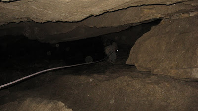
Gargantua Cave


Aug. 1st, 2009.

The entrance to Gargantua cave is located on the southern flank of the massive Mt. Ptolemy (in the Crowsnest Pass.)

Great fun! Long day.


My friend Jollin organised the outing... We started out as a bigger group with some of Jollin's colleagues from Alberta Agriculture... The Alberta Ag gang were only interested in hiking to Gargantua and exploring the first chamber. To get up the cart road, one guy quad'd and another dirt biked while the rest of us used mountain bikes.

Jollin, Matt, Chris and I dragged along some climbing gear and our plan was to descend the first rappel, explore a bit of the second level and climb back up the rope with Jollin's ascender. We parted company with the Alberta Ag dudes after lunch as we wanted a head start on exploration in the caves...

We got to the entrance around 2PM and met some people who had done the full route before and they encouraged us to follow them and do the full route. They figured it would take only 3 hours (give or take). They were a family group from Kamploops/Lethbridge and had approached the cave from the B.C. side...

They went on ahead after the first rappel, but luckily we were always able to catch up to them at the subsequent rapelling stations... despite us getting lost a couple of times. The map was pretty confusing and there's no signage or anything in the caves, but once you find those rap stations you know pretty much where you are. Still, one time we went down the wrong chamber, another time Matt rappelled down too low into a big hole and the ropes got wedged somehow and we had to fashion a pully system to pull him back up.

Anyways, the 3 hour estimate was a tad off... we started around 2:30 PM and didn't exit until 8:30. By the time we got back to where we stashed our bikes it was after 10 PM and it was pretty dark... so the bike back was pretty exciting as it was almost pitch black and we had to do all those stream crossings - plus there was a electrical storm that was pretty cool... lots of lightening but we only got rained on for a few minutes.

Ended up back at the cars at 11:30 PM and only got back to town at 2 AM!


Saturday, August 01, 2009

Ghostrider Peak (Mt. Hosmer, Fernie)


Sunday, July 26 (2009)
I forgot my camera in the morning(left it on top of my vehicle, no less...) so all pix here are by James Y. - who caught up to us at the summit despite a 1.5 head start. Tanks James! Good news was my camera was found after we got back to the parking. All's well that ends well!